This document contains the logs of the fourth singlehanded leg of the return trip with S/Y Thetis from the Greek Aegean island of Samos, to her base in Glyfada, near Athens. The leg is from Myrina, Limnos to Votsi, Alonnisos. The places seen on the way are: Planitis and Kyra-Panayia in Pelagos island, Peristera island, Patitiri, Gerakas, Steni Vala, and Chora in Alonnisos. The logs are illustrated with maps and photographs, and also include some historical and geographical descriptions of the places visited as well as several links to other related web sites.
Saturday September 12, 1998 Day 10
I went ashore early to buy fresh bread for the weekend. When I returned, Lefteris was waiting for me to go together to the Limenarchio. We did so, and we were informed that the ferry was due at 8:30 by which time both our boats must vacate the spot. Both boats prepared to leave. My plans were to go to Agios Efstratios. Nikos was there a few weeks ago with the Faneromeni and he told be that it is a rather primitive place worth a visit. Since it is only about 25 M from here it would be a shame not to see it. I loosened the anchor rode, shortened the docking lines, removed the passarella, and I was ready to jump ashore to untie the dock lines when several crewmen from John-Anna untied them for me, while Carol was offering me a cup of coffee. It is really amazing what a large crew can do!
Thetis left first, followed by John-Anna. We were on our way again. The time was 0837. While preparing and raising the anchor a new Navtex forecast had been received. It predicted for the Northeastern Aegean (where we were):
N 5 TO 6 VERY SOON 4 TO 5 LATER SW
FROM 0400 UTC STRONG WSW WINDS
WILL PREVAIL AT ALL HELLENIC SEAS
While we were heading for Agios Efstratios, I read from Heikell’s notes on its harbor that it is open to the SW. This was asking for trouble, if the weather is going to change to SW. I quickly revised my plans and headed instead to Planitis in the Pelagos island of the Sporades although it was over 50 miles away. The wind where we were was 10-15 knots NE. We sailed at a broad reach with the full main and genoa, but the wind was not very strong and we only made 4 knots. Eventually I started the engine and motor-sailed at 2,000 RPM. According to the GPS our speed over ground was now 7 knots. It was a very comfortable ride.
Since I was already going to the Sporades, it was too bad that I did not have the proper C-map cartridge. I was sort of spoiled by the amount of detail that it provides which is hard to be matched by paper charts. I only had 4 charts for that region while the cartridge contains over 30. I called Nikos with the Autolink and left a message asking if he could send the cartridge to me in Alonnisos.
Time went by very quickly with me sunning and reading on deck. While I was having lunch, I was paged by the Autolink. I called back the number that paged me. It was Rozina. She was with Nikos in Aegina. They did have the correct cartridge, all packaged and ready to go, but they could not mail it until Monday morning. It should be in Alonnisos by Wednesday. I also tried to call my wife, Alice, in Washington, D.C. I could hear her very well but she could not hear me. I suppose that we were too far from the transceiver in Limnos. Very frustrating! Other than having to motor-sail this was as easy a passage as it could possibly get. Time flew. There was only a very modest swell which made the ride even more pleasant.
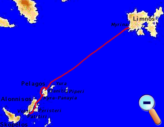
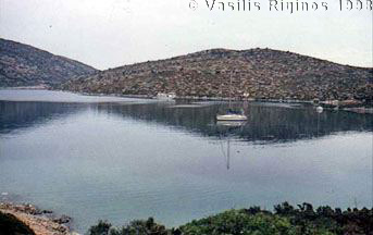
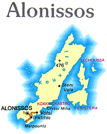
We arrived in Planitis (Πλανήτης) [39° 21' N 24° 04.5' E] at 1740, the distance from Myrina was 54.8 M. There were only two other yachts and three fishing boats in this large anchorage. The wind was a mild 8 knot breeze, still from the NE. I anchored in the SE corner, anticipating a change of wind direction, at 5 m depth and with about 40 m chain rode. No problems with the anchoring.
The island of Pelagos (Πέλαγος), sometimes referred to as Kyra-Panayia (Κυρα-Παναγιά), is an uninhabited island. It has two very good anchorages: Planitis in the East and Kyra-Panayia in the West. Planitis is a large landlocked bay, surrounded by green vegetation. On the E side of the island there is an old, now abandoned, monastery. The whole island is the property of the Megisti Lavra monastery in Mount Athos. They have leased grazing rights to some people in Volos, who own several large herds of goats. Several times a year they come and herd their goats. It is also a sanctuary for marine mammals and birds, and fishing is prohibited.
The organization for the preservation of the Mediterranean Seal, Monachus Monachus or as it is locally known, MOm operates out of Alonnisos. They operate an information pavilion in Patitiri, a seal rescue station in Steni Vala, and a patrol boat that helps with the enforcement of the regulations of the marine sanctuary, also referred to as the Marine Park. The regulations prohibit any vessel to approach within 1 M the islands of Piperi and Yura and allows anchorage only in Planitis and Kyra-Panayia in Pelagos and in Skantzoura. Professional fishing is strictly prohibited within the park and only very limited fishing is allowed in designated areas. In the summer of 1996, my daughter Corinna spent a few weeks in Patitiri as a volunteer for MOm.
As I was sipping my ouzo in the cockpit, the MOm patrol boat entered the bay and went from boat to boat handing out a pamphlet outlining the regulations of the Marine Park. When they approach Thetis, I asked about Stamatis, Corinna’s friend who is one of the two skippers of the patrol boat. It turns out that he was on onboard and we got acquainted. He will be off duty next week and he will look forward to getting together with me in Patitiri.
In the mean time, the wind had shifted to SW, and after dusk it died out completely. The water in the bay was as flat as thick yogurt. The surrounding hills had taken a golden hue and the sky, shades of blue-green. It was a magic hour again! A few stars became visible as the sky slowly darkened.
I made my dinner from leftovers and ate it in the cockpit. The night was very clear and lovely with lots and lots of stars. It was still very calm, despite the warnings now coming over the Navtex for a SSW gale. In the utter stillness of the air I could almost sense the imminent change of weather.
Sunday September 13, 1998 Day 11
The barometer dropped since last night by 10 mB. The Navtex predicted, for the Northwestern Aegean, SSW winds of force 6-7 and gales for the Ionian Sea. A low pressure front was moving eastward from Italy. Here in Planitis, the wind was from the SW at 10-15 knots while the water in the bay was flat.
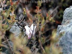
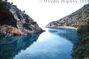
I launched the zodiac and went ashore for a walk. I found a path and followed it. There were a few cyclamens blooming, the first I had seen this year. The path was pleasant, there were herds of goats and a flock of pheasants. After walking for 1¼ hours, I came to a lovely little fjord at the NE side of the island. The beauty of the fjord was spoiled by garbage. Can people ever learn to respect this beautiful land and sea that we have inherited? Why do they throw all these plastics and oil overboard or dump them from land to the sea?
By the time I got back on Thetis the SW wind had gathered more force and it was blowing at over 25 knots. I spent some time cleaning the boat from all the dust she has collected during her windy stay in Myrina. I made a potato salad for lunch with the potatoes I had brought from Kalami.
I wanted to call Alice in Washington but there was no VHF signal in Planitis. So, I raised the anchor and motored outside the bay until I could get a signal through. I then called her with the Autolink. I also called Nikos to confirm that I will be going to Alonnisos but that I might be holed up in Planitis for the next few days to avoid the gale. The wind was now blowing over 30 knots.
I got back in the bay and anchored at a different spot in 4.7 m of water. The barometer had fallen from yesterday’s 1010 to 998 mB. The Navtex was now issuing a gale warning for this region. Just to be on the conservative side, I deployed the second anchor. In this very protected bay, most likely, this is an over reaction on my part.
Within half an hour after setting the second anchor, the wind settled down to under 20 knots. Later the Navtex canceled the gale warning and revised the forecast to force 5-6 SSW. But it warned of a new gale moving to Greece from Italy.
Monday September 14, 1998 Day 12
The barometer has risen to 1005 mB, and the Navtex stopped issuing any gale warnings but forecasted SW winds of 5-6, soon force 7. I lifted the second anchor, stowed it, removed the outboard from the zodiac, and raised the primary anchor. Once again the knot meter did not work, so we stopped and while drifting, I cleaned its sensor. We departed Planitis at 0910 towing the zodiac.
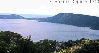
The wind was from the W at 15-20 knots, dead against our course. We motored to Kyra-Panayia, the lovely anchorage on the W side of Pelagos. We have stayed in this well-protected-from-the-meltemi anchorage many times, today though it was not tenable. Too much swell entered the cove, driven by the west wind. I decided to go to the very lightly inhabited island Peristera (Περιστέρα) or Peristeri which is just across and S of Alonnisos. We headed for the Vasiliko cove which both pilot books describe as offering excellent protection.
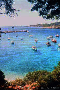
We arrived in Vasiliko (Βασιλικό) [39° 12' N 23° 58.6' E] at 1310 (16.1 M). The only place protected from the W wind was very deep. I anchored at 20 m depth over weed, letting out all of the 50 m of chain. Two other sailboats were anchored nearby. It was hot, 30°C, inside the cabin. I put out the tent, despite the wind. I had a swim and started having lunch. The wind was gusting, now from the W, now from S, and sometimes from the E. Eventually one of the other boats dragged her anchor and started drifting toward Thetis. With the table still in the cockpit, I started the motor and put it forward, dragging my anchor but avoiding the impending collision. By that time the third boat, a large catamaran, was also dragging. When we reached deeper water, away from shore and the other boats, I raised the anchor which was totally fouled with weed. After getting rid of the table and mounting the autopilot I headed away from Vasiliko to look for a better place.
I found a nice cove 2.1 M W of Vasiliko [39° 10.2' N 23° 58.2' E] and just before the SW point of Peristera. It was well protected. I anchored at 10 m depth. Since the cove was too narrow to allow any swinging room, I set the second anchor and took a shore line from the stern to a rock, on shore. Thetis was very secure, tucked inside this lovely but nameless little cove.
As evening progressed, the wind died out and the only sounds were the goat bells and the cries from a large flock of seagulls roosting on the rocks. The only flaw was the jetsam on the tiny beach.
I repaired the radar screen mount on the chart table that was coming loose by replacing its screw.
Tuesday September 15, 1998 Day 13
The day started with very dark clouds on the horizon. Exactly one year ago we were in Kastellorizo, and Aliki left for Athens while I sailed to Karpathos and Crete. Two years ago, 1996, Thetis was in Ermioni where Lewis and I were just starting our trip to Malta and Sardinia. This year’s trip feels like a gift. An extra. Something that looked impossible to me last winter when I was sick. As I am getting stronger I am beginning to dream again of more trips.
Despite the clouds, the day was warm. At 8:00 AM the temperature was 24°C (75.2°F). The Navtex forecast for the Northwestern Aegean called for WSW wind (Πουνεντό-Γαρμπής - Pounento-Garbis) force 5-6 soon changing to WNW (Πουνεντό-Μαΐστρος - Pounento-Maistros) and from tomorrow the winds are going back to the northerly meltemi. There was a low pressure cold front now over the NE Balkans moving to the E. Maybe, if we are lucky, we could escape this front. As the day progressed the clouds disappeared. I started preparing to leave this nice cove for Alonnisos. It took me less than one hour to untie and stow the cavos (shore line), to remove the outboard and oars from the zodiac, to loosen the chain and raise the second anchor with the windlass, to stow the anchor and its rode, and finally to raise the primary anchor. We departed at 0920. The wind was 10-15 WSW. We first motored to Steni Vala (Στενή Βάλα) [39° 11.5' N 23° 55.5' E] in Alonnisos, just to see it, as it was just across the narrow channel. There were several sailboats in the small cove, most of them moored bow-to. There were also a number of attractive looking tavernas. The concrete quay is new and it is not described by either Heikell or by the Portolanos.
We then motored to Patitiri, the main harbor of Alonnisos but it did not look too comfortable, so we backtracked to Votsi, just E of Patitiri. Votsi [39° 08.9' N 23° 52.4' E] is more picturesque and definitely quieter and more protected. We arrived at 1025 (5.9 M). Following the example of the local boats, I anchored facing to the S and set the second anchor from the stern to the N. I snorkeled and verified that both anchors were well dug-in. The water was very clear.
The distance we traveled from Myrina, Limnos to Votsi, Alonnisos was 83.52 M and we were traveling for 15.8 hours.
Alonnisos (Αλόννησος) has about 1,100 inhabitants and an area of 62 km², and its tallest peak, Kavouli is 470 m. It is a green island with many olive trees, fig trees, almond trees, etc. In the antiquity Alonnisos was occupied by the Athenians under Kimon and then by Philip of Macedonia. It was later a place used by pirates. The ruins of the ancient city of Iko (Ικώ) have been excavated near Kokino Kastro (Κόκκινο Κάστρο) where some walls and some inscriptions have been found. Also on the little island of Vrachos (Βράχος) were found some Paleolithic tools.
Votsi (Βότση), although more crowded, is still as attractive as I remember it from when I was last here in 1991. I was with Nikos and Rozina with the Faneromeni on our way to visit Mount Athos. I was also here in 1986 with Thetis and the whole family (where have these 12 years gone?).
I got off the boat and called Nikos. He did send the C-Map cartridge yesterday and it could already be here. Last night, he had a mishap. A sail boat fell on the Faneromeni, as she was anchored in the crowded harbor of Aegina, causing some damage.
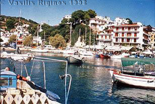
I then walked up the hill and down again to Patitiri (Πατητήρι), about 40 minutes, and checked in the Post Office. No, the package was not in yet, I did hope that it comes by tomorrow. I then rented a motor scooter, bought some excellent fresh bread, and drove back to Thetis for lunch.
After lunch, I rode the scooter to Steni Vala to look at the MOm seal rescue station. It seemed abandoned and it was very disappointing. I used a public phone to call Aliki in D.C. I then drove to the northernmost cove of Gerakas (Γέρακας). It is a lovely ride. The island is very green, full of pine trees and olive trees. The light was wonderful and all the colors were very vivid. As the road is high up, it affords a fantastic view of Peristera, Skantzoura, Skyros, and Evia on the S and Pelagos, Yura, and Piperi on the N.

On the way, I came across one of the votaries one often sees along the roads in Greece. This one, however, was not just an ordinary votary. It was a votary to Saint Riginos (Άγιος Ρηγίνος)! I am not Saint Riginos, we just share the same name. He is the patron saint of Skopelos.
Gerakas is a very lovely and remote place, but terribly exposed to the North winds. A fisherman told me that MOm is moving their operations from Steni Vala to here.
The ride back was less pleasant. Dark, ominous looking clouds rolled in from Evia, the temperature dropped, and it started to drizzle. By the time I got back to Votsi it was raining in earnest. Shortly after I got onboard Thetis the rain stopped and the sun came back. The wind was a modest one of 5-8 knots from the NW. Unfortunately, the rain cooled down the sun shower and I did not have any hot water for a much desired shower.
In the evening I went back to Patitiri. The MOm patrol boat was gone, but I found the MOm pavilion and saw their exhibit. There I also met Corinna’s friend Dina Triantafylou. She is a very pleasant girl of a stunning Mediterranean beauty with huge black eyes. I bought a number of MOm shirts. There was no sign of Stamatis in any of the cafés suggested by Dina. I had an indifferent fish dinner at one of the sea front restaurants, and drove back to Thetis. It was a quiet night.
Wednesday September 16, 1998 Day 14
I woke up slowly, taking my time to get going. I transferred one jerry can of fuel to the main tank and taking advantage of the scooter, refilled it at the gas station over the hill with 22 L of fuel. I did some light shopping for supplies, and also bought the Greek chart 331 covering the Sporades. The C-Map cartridge did not arrive but they are expecting another delivery later in the day. If it arrives I may leave. The Navtex forecast was for only force 5 NW wind. The next Navtex message reads:
151450 UTC 98 SARWAR 35/98
SAILING YACHT 'AGIOS MINAS'
WITH TWO (2) PERSONS ON BOARD
IN DISTRESS DUE TO FLOODING
IN POSITION 39 35N 023 56E
(20 NM SOUTH OF KOUFO SITHONIAS)
SHIPS IN VICINITY ARE KINDLY REQUESTED
TO RENDER ASSISTANCE
We were at [39° 09' N 023° 52' E], not very far from the distressed yacht. I drove back to Patitiri and actually did find Stamatis. He was getting ready to go with the MOm patrol boat to search for the yacht that had issued the distress call. He was upset because her problem was known before she sailed. As a mater of fact, the Coast Guard had forbiden her to sail and they departed surreptitiously. Now a massive rescue effort was under way.
I left Stamatis at the harbor and went back to the Post Office. The package had arrived! After getting the package, I used the scooter to transport a case of drinking water to Thetis. Once again I drove up the hill and returned the scooter and walked back to Votsi and had lunch aboard Thetis. I contemplated going to Scantzoura for the night since the wind was very weak but, chickened out because Skantzoura is exposed to the West and the forecast was for NW winds.
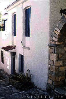
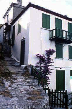
Later in the afternoon I took a walk (5 km) to Chora or Alonnisos, the main town of the island, which overlooks both the NW and the SW directions. The town was destroyed in 1965 by an earthquake. At that time Greece was under a military junta. They ordered the town to be evacuated and set temporary housing for the inhabitants at Patitiri. The inhabitants were prevented from going back and rebuilding but were ordered to stay in Patitiri. Chora remained in ruins for several years. Some enterprising Germans bought a few ruined houses, for a very low price, and restored them. Their example was followed by more Germans and a few Englishmen. This process was just beginning in 1986. Now, more then half of the houses have been restored, most of them very tastefully. There is, alas, an overabundance of restaurants and bars. There are also a few art galleries but today they were all closed. Several of the streets have been re-paved with flagstones. By enlarge, the restoration of Chora is an example worthy of imitation. It is a far cry from what has been done to many other island towns, like Samos, where the old houses have been replaced with unattractive concrete boxes and the old cobblestone streets have been paved with gray cement.
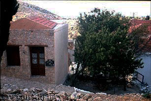
A house |
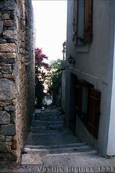
A street |
 The total hike lasted about 3 hours. It is really amazing how much distance one can cover at low speed (such as sailing or walking) if one is not in any hurry. Also amazing is how much more one sees and enjoys when the ground is covered at such a low speed.
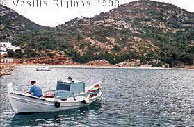
Later, after taking a much needed hot shower, I got off the boat again and walked to Patitiri (1.5 km). As I was strolling along the quay, looking over the boats, and contemplating at which establishment to sit down for an ouzo, a small motor-cruiser, with two people aboard, came in. I went to help with the lines. It was skippered by none other than Stamatis, Corinna’s friend from MOm. After tying the cruiser we all sat for a τσίπουρο (tsipouro - a drink similar to ouzo made by distilling the grapes after they have been pressed for wine), this is the preferred drink in Alonnisos. The other person, a very distinguished looking gentleman, was Mr. Nikos Spanos, the owner of the cruiser. They had been out fishing. Mr. Spanos lives in Belgium and comes here for the summers. He also owns a Swan 44. Stamatis is indeed a great character, full of life. He is a large middle aged man with a magnificent graying mustache. He has his own τρεχαντηράκι (trechantiraki - a small fishing caïque) Ταξιάρχης (Taxiarchis - archangel) with which he goes fishing. He lives in and by the sea. In the course of the evening, I also met his wife, 2 of his 3 children, and MOm, a very lively and friendly black kitten that lives aboard his boat. Later, we were also joined by an ancient local captain, Demetris, who is in the process of commissioning an old wooden cruiser which he bought in Italy. We discussed possible names, paints, engines, etc. In the spring, there was here a most horrific storm. The waves were reaching up to the 2nd floor of the buildings along the quay. Several boats in Patitiri were damaged, including Demetris’ cruiser. After a few pleasant hours, we all shook each others hands and parted company.
I had a very tasty and reasonably priced dinner at the Kamaki restaurant along the road leading up the hill from the harbor. Their shrimps and sword fish kebab were superb.